
 Information about Cambridge Castle
This is not a walk. The Castle Hill walk takes you up Castle Hill.
Doomsday Book: The castle is built.
Before 1574: The castle is expanded by Edward I. Fell into ruin.
1574 (map): This map shows St Peter and St Giles (which exist in all maps) and All Saints by the Castle. The castle is pictured.
1588 (map): All Saints still there.
1610 (map): All Saints disappeared.
1688 (map): Only a few buildings of castle left. New fortifications.
1730 (picture): Shows gatehouse (used as prison).
1830 (map): new prison building
modern (map): shows Shire Hall
The Doomsday Book was an account of all the land in England, who owned it and what it was worth, principally for taxation purposes. It is particularly useful, as it described what was there before the Norman Conquest and after. It describes 10 wards in Cambridge. Probably each ward had a church. The official who ruled over Cambridge was the Sheriff, and he would have lived in the Castle (although he would have had other houses).. The Doomsday Book is quite critical of him.
This single ward was accounted as two before 1066 but 27 houses have been destroyed for the castle.
---
Before 1066 the burgesses lent their ploughs to the Sheriff three times a year, now they are demanded on nine occasions.
Before 1066 they found neither cartage not carts; they now do so through an imposed due.
They also claim back for themselves from Picot the Sheriff the common pasture taken away through him and by him.
---
Picot himself has made 3 mills there which diminish the pasture and (which) have destroyed many houses.
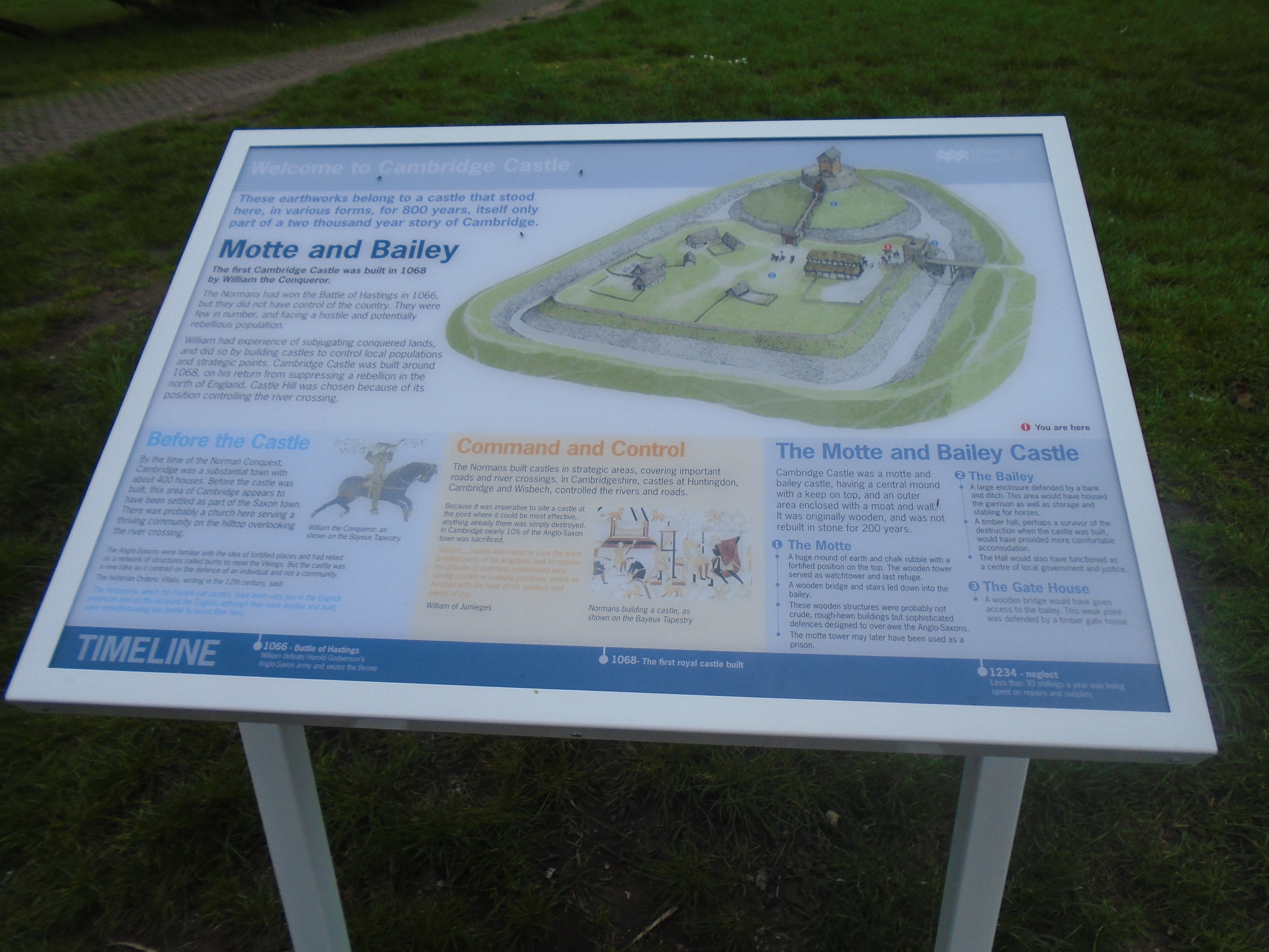
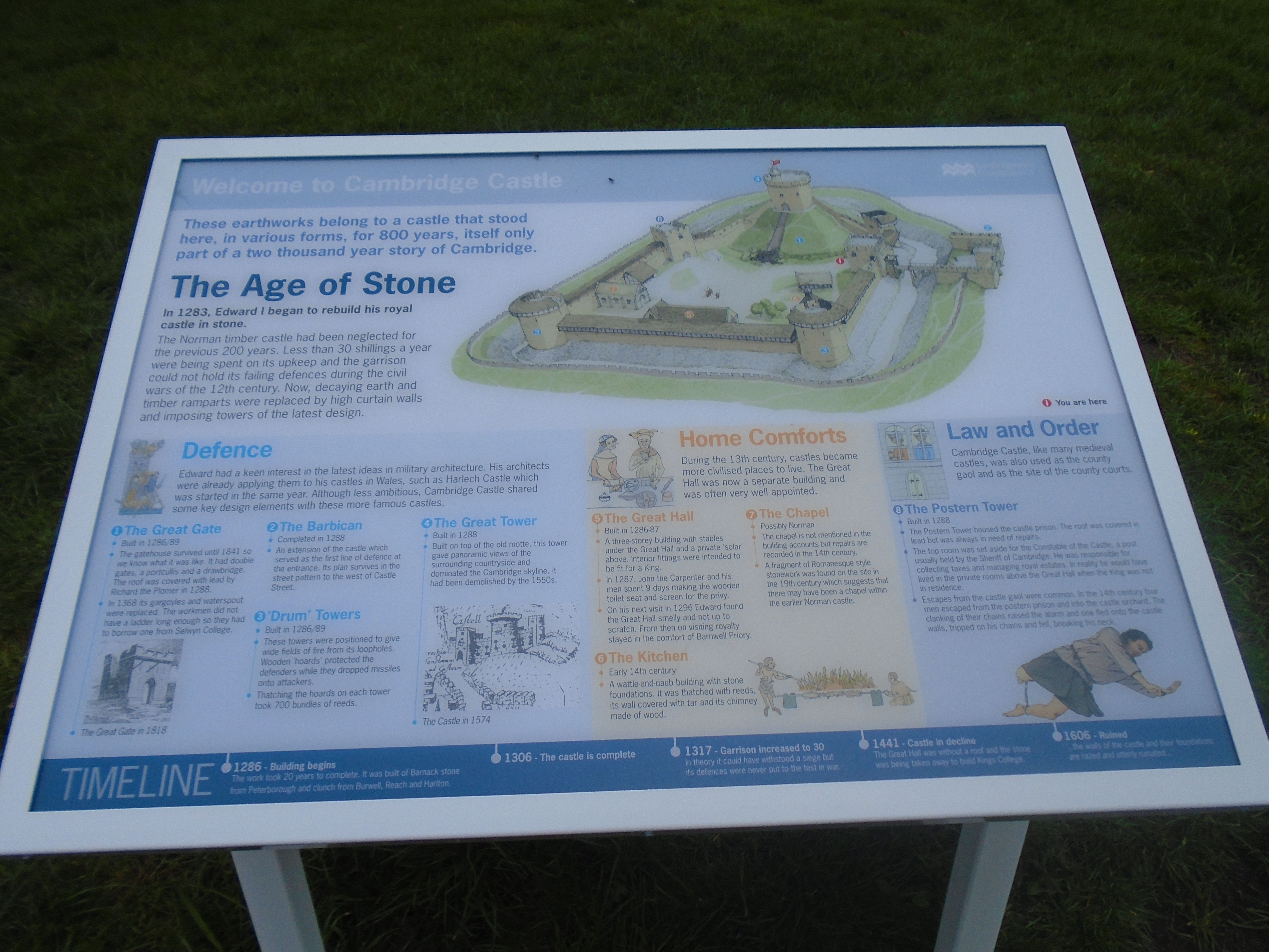
This account of Cambridge Castle is based on various maps. The earliest map is 1574, so here is a brief summary of the history of the castle before then.
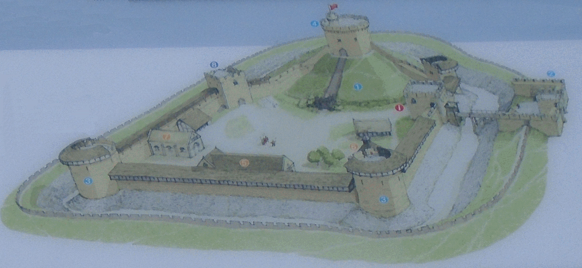
Originally built after the Norman Conquest of England in 1066 to control the strategically important route to the north of England, Cambridge Castle played a role in the conflicts of the Anarchy, the First and Second Barons' Wars. It was hugely expanded by Edward I. Edward's castle was four-sided, with circular towers at each corner, guarded by a gatehouse and a barbican. A circular stone keep was built on the motte. The result was a "major fortress in the latest fashion", albeit never quite completed.
From Edward III onwards, little money was spent on maintaining the property and by the 15th century the castle was in ruins. The castle hall and chamber were roofless by the 15th century, and Henry VI ordered these buildings to be destroyed and the stone reused for constructing King's College in 1441, with other parts of the castle being used to help build Trinity College's chapel. More stonework was given away by Mary I in the 16th century for building a mansion at nearby Sawston in the Fens, and other grants of stone given to Emmanuel and Magdalene colleges. By 1604 only the gatehouse, used as a jail, and the keep remained intact, with the surrounding walls described by contemporaries as "rased and utterly ruinated".
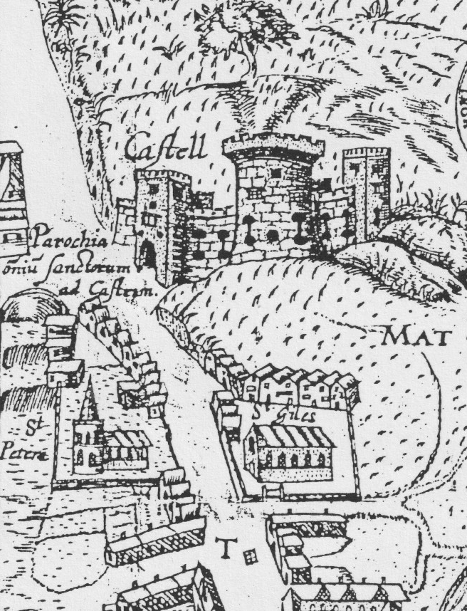
This is from the oldest map of Cambridge. It shows the castle as a notable building. Next to it is the Parish of All Saints by the Castle - a church which no longer exists. Below are St Peters and St Giles, and below that Northampton Street and Chesterton Road. There are buildings along Castle Street, but fields behind.

The castle, All Saints (All Hallows) are still there, plus St Peters and St Giles. Perhaps there is a sense of less housing around.

The castle, St Peters and St Giles are marked (2, N and O - marked in a key), but no All Saints. By the way, "Pithagoras House" still exists (School of Pythagoras). It's a little-known Norman building within St Johns. However, I think John Speed has it in the wrong place! It's south of Northampton Street. A hint, perhaps, that these early maps are not always reliable.
This map (and the previous two maps as well) show the Great Tower on top of Castle Mound, connected to the walls round the castle. The information board near Castle Mound (see bottom of page) shows a modern interpretation of the medieval castle. The Great Tower was built in 1288 and had been demolished by the 1550s. So these maps were not portraying an existing feature.

St Peters and St Giles are marked 8 and 7, but otherwise there are big changes. The castle is labelled, but very few buildings seem to remain. One is marked "the Shire House" and another "the Prison". You can also see new fortifications built round it.
The reason for all this is the English Civil War.. Civil war broke out in England in 1642 between the rival factions of the Royalists and Parliament. Cambridge Castle was occupied by Parliamentary forces in the first year of the war. Oliver Cromwell ordered emergency work to be conducted to repair the defences, resulting in two new earthwork bastions being added to the castle and a brick barracks constructed in the old bailey. The governor of Cambridge described in 1643 that "our town and castle are now very strongly fortified... with breastworks and bulwarks". The castle saw no further fighting during the war, and in 1647 parliament ordered the remaining fortifications to be slighted, damaged beyond further use. ("Slighted" means removing its capacity to be used for war.)
The king's justices visiting a county sat in the county court, so that a Sessions House was needed on the hill. Presumably the Edwardian hall served the purpose so long as its roof was on, but a Shire House, with a small court for criminal cases and a larger one for civil cases, was built in 1572 by Roger Lord North, who also built a small house for the juries to sit in.
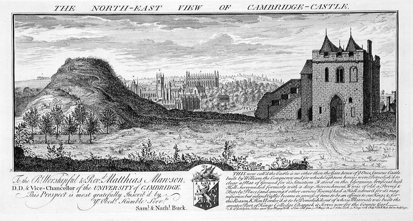
This is an engraving of Cambridge Castle in 1730, including the motte and the gatehouse jail (r). The description underneath reads:
This now called the Castle is no other than the Gatehouse of the once famous Castle built by William the Conqueror and for which eighteen houses were demolished to clear a flat of ground for its situation. It stood on the adjourning Artifical high hill surrounded formerly with a deep entrenchment. It was of old a strong and stately place, and (amoung other curious rooms) had a Hall admired for its magnificence, but inland castles became in process of time to be an offence to our Kings, and for this reason, King Henry VI ordered it to be demolished of whose material was built the greater part of Kings College Chapel. It serves now for the County Gaol.
It must be said that they never fitted the whole castle on top of Castle Mound! Also the "strong and stately place" was built by Edward I rather than William the Conqueror, whose original castle would have been built of wood. And the castle fell into disuse naturally, rather than Henry VI taking a dislike to it. I'm not sure that you could say "the greater part" of Kings College Chapel was built from the stone, as I would have thought that the carving throughout the chapel would require first class quality of stone, not rubble! But some was certainly used there. Parliament did take a dislike to the castle and slighted it in 1647. But apart from that, the account is OK!
The gatehouse remained in use as the county jail into the 19th century, being run, like other similar prisons, as a private business - the keeper of the castle jail was paid £200 a year by the county in 1807 (equivalent to £20,000 in 2023).
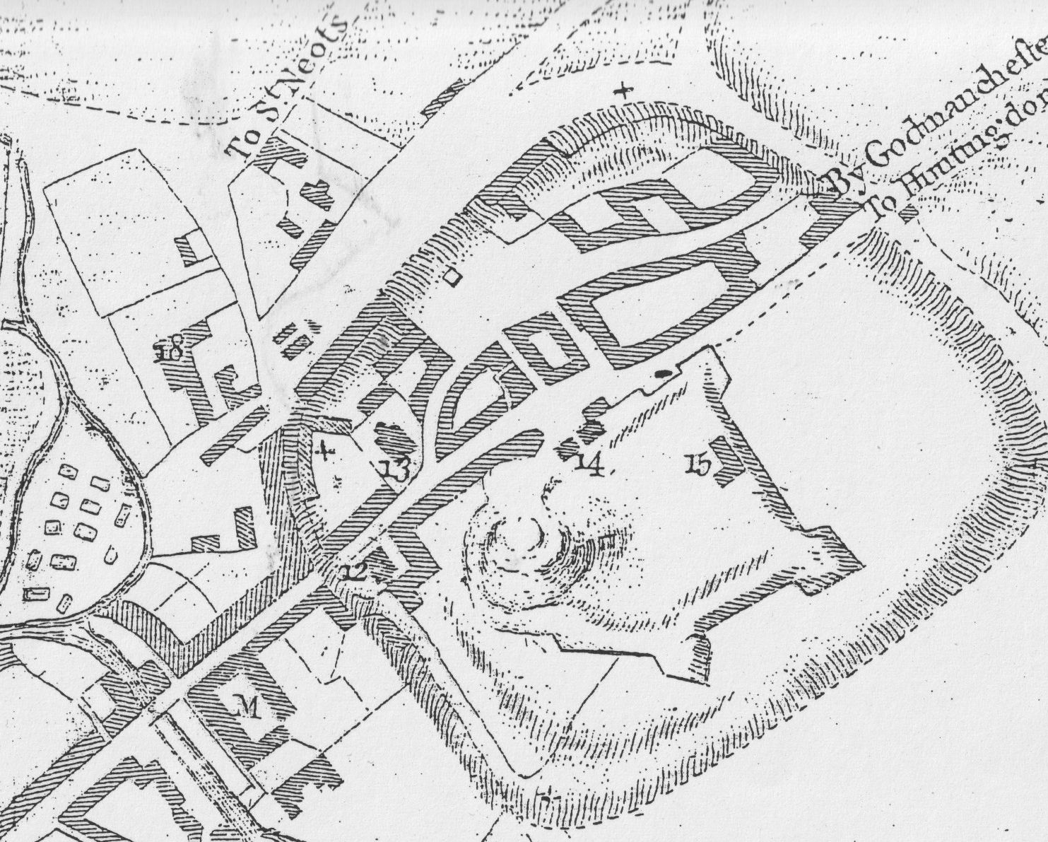
The key gives the meaning of the numbers - 12 isSt Giles and 13 is St Peters. d is a charity school, not marked in previous maps.14 is described as "Castle". b is described as "Castle". 15 is "Bridewell" (prison). 18 is Pythagoras School (in the right place!)
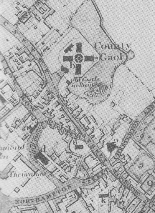
The key gives the meaning of the numbers - 9 is St Giles and 8 is St Peters. b is Goal, marked as Coiunty Gaol. You can see that it is a completely different shape. It also marks "Old Castle in Ruins".
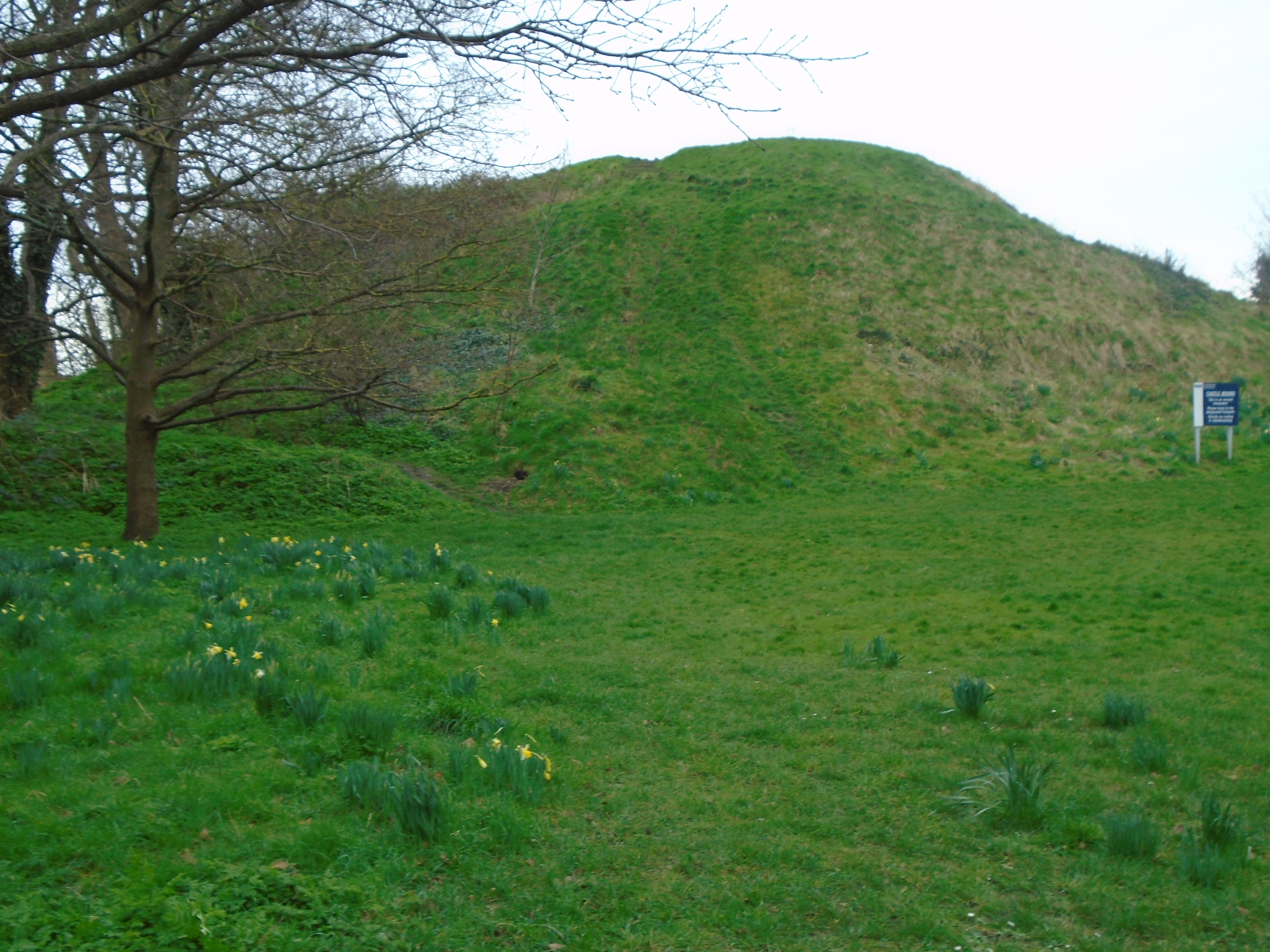
The castle rapidly deteriorated after the slighting in 1647, and the remaining walls and bastions were taken down in 1785, leaving only the gatehouse and the earth motte.
A new county prison was built in the grounds of the castle's former bailey. The new prison was built by G. Byfield between 1807 and 1811 with an innovative octagonal structure, influenced by the designs of the prison reformer John Howard; the castle gatehouse was destroyed to make way for a new county court building.
By the end of the 19th century, the jail was deemed to be surplus to requirements as Huntingdon jail was sufficient to hold prisoners from both Huntingdonshire and Cambridgeshire. By 1920 the building had become a branch repository of the Public Record Office and remained so until 1928 when it was acquired by Cambridgeshire County Council. The jail was demolished in 1932 and the bricks used to build Shire Hall on the same site.
Here is a modern map of the area:

At the bottom of castle Mound, there are information boards about the castle - see below. Click on a photo for a larger (readable!) version.

Castle Mound still exists, and you can see a little of the earthworks behind it, which belong to the Cromwell fortifications.

There is also a much weathered gargoyle spout in the grounds of Shire Hall.

© Jo Edkins 2025 - Return to Walks index