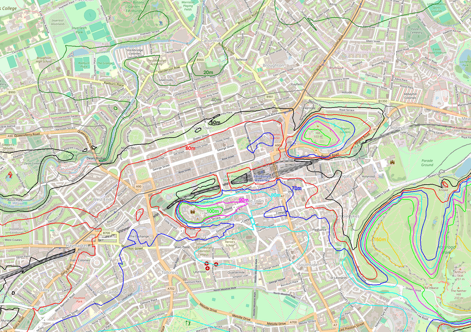
Contour map of Edinburgh |
We live in Cambridge. It is flat. Edinburgh was a servere shock to the system...
Here is a contour map of the city centre, below. It shows the main features.
The Castle is seriously up in the air. Then there is a ridge leading down to Holyrood Palace, which is low down. This ridge is called the Royal Mile, but my father (who had a Scottish mother) called it the Hogback, which is more descriptive. (It's more than a mile, anyway.) This ridge is generally called the Old Town, although I suspect that Grassmarket was also part of the Old Town. The New Town is the flat bit to the north of the Royal Mile. The New Town is not a problem (being so flat) but the Old Town needs a certain amount of consideration.
The Royal Mile has lots of alleyways and a few roads leading off it. These tend to slope, a lot, especially near the Castle. In fact, the alleyways are often stepped - lots of steps! There are some roads (unstepped). Cockburn Street takes you from Waverley Station to the Royal Mile, ending up near the Tron. Victoria Street / West Bow takes you from Grassmarket to the Royal Mile, ending up near St Giles. Both of these wind rather than taking the shortest route, a hint that they are steep (since the winding makes the slope easier). There are quicker alleyways, but these will have steps. At the start of the week, we avoided these, but once we got fit, we tackled them to save time. There is another southwards road from the Tron, Blair Street, on the Royal Mile, down to Cowgate. This doesn't wind, as the Royal Mile isn't so high at this point, but it is a steep road. I would hate to tackle Edinburgh in icy weather!
There are two roads which look as if they pass over the Royal Mile from north to south called the North / South Bridge, and George IV bridge. Be warned. They are, indeed, bridges. They pass right over Cowgate. You can see this on the map as the contours seem to get confused at that point. If you want to get down to Cowgate or Waverley station, you are going to have to get off these streets, and find a road or alleyway down to the right level (such as Blair Street or Scotsman Steps). On the other hand, if you want to get beyond Cowgate, these bridges can be useful.
This shows that there is not only a ridge along the Royal Mile, there is a valley to the south of it. This is Grassmarket and Cowgate. Our flat was in Cowgate Head (where these two streets meet). The day we arrived, we had to walk over the Royal Mile, up and down, up 54 steps to our flat (no lift), dump the luggage, walk down the stairs, then back over the Royal Mile (up and down), to get food at M&S, then back over the Royal Mile (up and down) and crawl up 54 steps to the flat. And collapsed...
Since the Grassmarket is a valley, there can be steep parts to its south. There is an alleyway called the Vennel at the end of Grassmarket, with good views of the Castle. And lots of steps...
It is possible to walk right round the Castle, starting from Princes Street Garden, through St Cuthbert Kirkyard, and end up in Grassmarket, keeping relatively on the flat. That shows what an odd lump of rock that the castle perches on.
There are other high areas in Edinburgh, Arthur's Seat next to Holyrood Palace (with the Salisbury Crags), and Calton Hill. But those are areas which you go round rather than up and over (unless you are looking for a good view). The Calton Hill area has a stepped alleyway called Jacon's Ladder taking you from Calton Road to Regent Road.